 1 hour ago
Led by Togo and supported by the Africa Group, the initiative promotes the Equal Earth projection. Its sponsors argue that the continued use of the 16th-century Mercator map makes Africa appear smaller and more peripheral than it is.
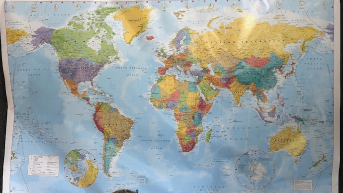
The immediate effect of the resolution may be limited because it is voluntary. (Representational Image/Reuters)
The United Nations has backed a move away from the familiar Mercator world map in favour of a projection that shows countries closer to their true relative sizes.
The UN General Assembly adopted the “Correct the Map” resolution on Friday by a vote of 164 to one, with six abstentions. The United States was the only country to oppose it.
Led by Togo and supported by the Africa Group, the initiative promotes the Equal Earth projection. Its sponsors argue that the continued use of the 16th-century Mercator map makes Africa appear smaller and more peripheral than it is.
The African Union welcomed the vote as a “historic step” towards accurate and equitable global cartographic representation. The initiative was first endorsed by the African Union Assembly in February before being taken to the UN.
“For centuries, the Mercator projection distorted global geography, shrinking Africa to the size of Greenland when our continent is actually 14 times larger,” the African Union said.
It said the resolution would promote equal-area maps such as Equal Earth in classrooms, the media and international institutions, allowing the world map to reflect Africa’s “true scale, weight and place in the world”.
“A fair world begins with a fair map,” Togo’s Foreign Minister Robert Dussey said ahead of the vote.
WHAT IS THE MERCATOR MAP?
The Mercator projection was developed by Flemish cartographer Gerardus Mercator in 1569.
Turning the Earth’s curved surface into a flat rectangular map inevitably causes some distortion. The Mercator projection preserves direction and the shapes of smaller regions, making it particularly useful for maritime and aerial navigation.
It does this, however, by increasingly enlarging land masses as they move farther from the equator and closer to the poles.
Countries and territories in northern latitudes consequently appear much larger than they are, while regions closer to the equator, including much of Africa, look relatively smaller.
HOW DOES IT DISTORT THE WORLD?
One of the clearest examples is the comparison between Greenland and Africa.
On many Mercator maps, Greenland appears roughly comparable in size to Africa. In reality, Africa is about 14 times larger.
The projection also exaggerates the size of Europe, North America and Russia relative to Africa, South America and parts of Asia.
The Mercator map is not geographically wrong in every respect. It was designed for navigation rather than comparing the area of continents.
The controversy concerns its widespread use in classrooms, offices and public communication, where viewers may assume that it accurately reflects the relative sizes of countries and continents.
WHAT IS THE EQUAL EARTH PROJECTION?
Equal Earth is an equal-area map projection. It displays countries and continents in proportion to their actual surface areas while retaining recognisable shapes.
Africa therefore appears substantially larger than on a Mercator map, while land masses closer to the poles appear smaller.
Supporters say it offers a more accurate visual understanding of the world and reduces the prominence traditionally given to Europe and North America.
Togo described Equal Earth as offering the “best perception” of the relative size of the continents.
IS THE UN DECISION BINDING?
No. The General Assembly resolution is not legally binding and does not compel countries, schools or technology companies to stop using Mercator maps.
It encourages the wider adoption of Equal Earth for education, public communication and other purposes where accurately comparing the sizes of countries and continents is important.
The resolution also does not challenge the use of the Mercator projection for maritime or aerial navigation, where its ability to preserve direction remains valuable.
The initiative is aimed at changing how the world is represented on general-use maps, not eliminating Mercator from specialised navigation.
WHY DID AFRICAN STATES PUSH FOR THE CHANGE?
African countries argue that maps influence how people understand global power, importance and geography.
Because the Mercator projection makes Africa appear smaller, campaigners say generations of students have been given a distorted impression of the continent’s scale.
The African Union Assembly endorsed the “Correct the Map” campaign in February. Togo later led the initiative at the UN with the backing of the Africa Group.
The African Union said the resolution recognised that the choice of a map was not merely technical but also affected how Africa’s place in the world was perceived.
Togo linked the campaign to broader African efforts to confront colonial-era legacies. Dussey said the Mercator map’s widespread use was partly a consequence of European colonisation.
He stressed, however, that the initiative was not an attack on Europe or any other civilisation.
“The world is changing. Africa also is changing,” he said.
WHY DID THE US OPPOSE THE RESOLUTION?
The United States was the only country to vote against the measure.
Washington said the resolution promoted an “ideological agenda” and distracted the UN from what it described as genuine challenges involving international peace, prosperity and relations between countries.
Supporters rejected that argument, maintaining that accurate geographical representation was an issue of education and fairness.
WHAT HAPPENS NEXT?
Togo plans to replace the Mercator projection in its school geography materials by the end of the year.
“Togo will be the first country to change our own geography books,” Dussey said. “In the classroom, we need to change it to give an example to all the countries in the world.”
The country will also urge other governments, schools, international organisations and technology companies to adopt Equal Earth maps.
Togo plans to consult African Union members and supporters in other regions over the next six months to develop a strategy for wider adoption.
Dussey said the discussions would need to involve companies providing digital maps, GPS services and other location-based technologies.
The immediate effect of the resolution may be limited because it is voluntary. Its wider impact will depend on whether schools, publishers, international organisations and technology platforms change the maps they use.
- Ends
Published By:
Aprameya Rao
Published On:
Sep 4, 2026 23:18 IST