A rare Gulf Coast snowstorm brought historic snowfall to Texas and New Orleans, grounding flights, closing schools, and plunging temperatures to record lows, with freezing conditions expected through midweek.

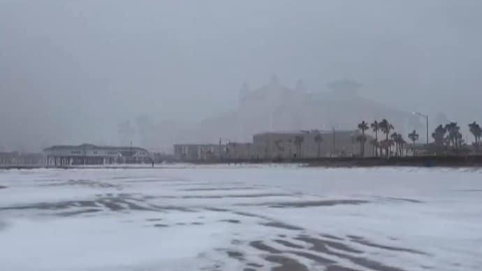
A rare winter storm blankets a beach in Galveston, Texas, in snow. (AP Photo)
NEW ORLEANS: A rare frigid storm charged through Texas and the northern Gulf Coast on Tuesday, blanketing New Orleans and Houston with snow, closing highways, grounding nearly all flights and canceling school for millions of students more used to hurricane dismissals than snow days.
The storm prompted the first ever blizzard warnings for several coastal counties near the Texas-Louisiana border, and snow plows were at the ready in the Florida Panhandle. Heavy snow, sleet and freezing rain are expected around the Deep South as a blast of Arctic air plunges much of the Midwest and the eastern U.S. into a deep freeze.
Nearly 2,000 flights to, from or within the US were canceled Tuesday, with about 10,000 others delayed, according to online tracker FlightAware.com. In Texas, both Houston airports suspended flight operations starting Tuesday in expectation of hazardous conditions.
Nearly every flight was cancelled at New Orleans Louis Armstrong Airport, though officials said the airport itself would remain open “as long as the conditions are safe.” Most airlines plan to resume normal operations Wednesday.
The East Coast was blanketed in snow while people from the Northern Plains to the tip of Maine shivered in bitterly cold temperatures from the frigid arctic air mass that plunged temperatures well below normal. Dangerously cold wind chills were expected through Tuesday morning.
In New Orleans, 65-year-old Robert Hammock donned a beanie and rallied himself and his border collie Tillie for a snowy, frosty morning walk.
“She loves the snow,” Hammock said as Tillie sprawled happily in the slush on the sidewalk. “I’m from south Alabama, so I hate the snow.”
Winter storm warnings extended from Texas to North Carolina on Tuesday, with heavy snow, sleet and freezing rain expected to move eastward through the region into Wednesday. Meanwhile, a state of emergency was declared Monday night across at least a dozen counties in New York as heavy lake-effect snow was expected around Lake Ontario and Lake Erie through Wednesday — with 1 to 2 feet (30 to 60 centimeters) possible — along with extreme cold temperatures.
Snow on the Gulf Coast
Ahead of the storm, governors in Georgia, Louisiana, Mississippi, Alabama and even Florida declared states of emergency and many school systems canceled classes Tuesday. School closures were planned in some coastal communities in North and South Carolina.
It’s the first time Houston has seen snowfall since a winter storm knocked out power to millions and killed more than 200 people in 2021, according to meteorologist Hayley Adams at the Weather Service in Houston.
Snow is rare in Texas’ largest city. In February 1895, a two-day storm dropped a record 20 inches (50 centimeters) on metropolitan Houston.
Officials said one person has died from hypothermia in Georgia. Forecasters say snowfall could stretch from north Georgia, through Atlanta, and into southern portions unaccustomed to such weather.
Parts of Florida’s Panhandle were already coated white Tuesday. Tallahassee, Florida’s capital, last saw snow in 2018 — just 0.1 of an inch, according to the weather service. Tallahassee’s highest snowfall on record was 2.8 inches in 1958.
The blizzard warning in effect until midday Tuesday was the first issued by the office in Lake Charles, Louisiana, according to meteorologist Donald Jones. Strong winds with heavy snow reduced visibility, and areas across the Gulf South that rarely see snow were expecting record-breaking snowfall, Jones said.
Louisiana transportation agency workers worked through the night to prepare bridges and roadways.
Baton Rouge, Louisiana, already had 1.5 inches of snow coating downtown Tuesday morning, according to the Weather Service — the capital city’s first snowfall since 2018.
“The last time we saw snow of this magnitude was way back in 1960, and prior to that, the previous snowfall record that even stands to this day was way back in 1895,” Jones said. “By modern standards this is going to be a historic and very memorable storm.”
In suburban New Orleans, as a rare snowstorm began to cover the roads, a Harahan police officer rubbed his ungloved hands to warm them as he responded to a church security alarm. Sleet turned to snow as the sun rose, with scarcely a car on the road.
Before snow and sleet began falling Monday night, Houston Mayor John Whitmire asked residents to stay off the roads, noting that above-freezing temperatures weren’t expected until Thursday.
When it last snowed in Charleston, South Carolina, in 2018 , the airport closed for four days as crews struggled to de-ice runways. In 2014, huge chunks of melting ice dropped from cables of the massive Ravenel Bridge, shattering windshields. Officials now close the bridge until the ice fully melts.
Return of the Arctic blast
Frigid cold persisted across the eastern two-thirds of the country with multiple record lows possible through midweek, especially across the Gulf Coast and portions of the Southeast, the weather service said. Normal temperatures were only expected to return slowly by the end of the week.
Wind chills were expected to reach minus 30 to minus 50 degrees (minus 34 C to minus 46 C) at times across the Dakotas and into the Upper Midwest, posing an extreme risk of hypothermia and frostbite. Subzero wind chills were forecast from the Central Plains eastward through Wednesday night.
The weather service issued cold weather advisories across the Great Lakes region.
This latest cold snap comes from a disruption in the polar vortex, the ring of cold air usually trapped at the North Pole.
Houston’s low temperature Tuesday will be about 18 (minus 8 C), according to the weather service, which is low enough for water to freeze in pipes, expand and then cause the pipes to burst.
Published By:
indiatodayglobal
Published On:
Jan 22, 2025

 20 hours ago


